Showing posts with label Conservation Information. Show all posts

Monday, April 29, 2013

Cover Crop Field Day in Allen County


by Cassandra Vondran
Cassandra is an Indiana State Department of Agriculture Resource Specialist for the Division of Soil Conservation in Allen and DeKalb Counties covering the Western Lake Erie Basin and has been with the Division for nearly 18 years.

Many benefits are associated with cover crops:  erosion control, increased microbial activity, increased nutrient cycling, increased organic matter, increased infiltration, and increased crop yields. To educate area farmers, a cover crop field day was held on April 10th at Ron Miller’s farm north of Woodburn, IN.  The field day was sponsored by the Allen County SWCD as a part of an Indiana Department of Environmental Management 319 grant for the Upper Maumee River Watershed Project. 

Scott Haley and Derek Thompson showing soil health demonstrations

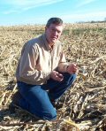
Scot Haley, NRCS Area Soil Scientist, and Derek Thompson, DeKalb County NRCS District Conservationist, kicked off the field day by showing soil demonstrations.  Mike Werling, a farmer and a contract employee through the St. Mary’s Watershed Initiative, provided additional comments.  The demonstrations showed the benefits of utilizing cover crops. Producers then were able to look at soil pits in fields that had cover crops.  

Attendees look on as Scott Haley describes cover crop roots in a soil pit

Soil pits were dug about three to four feet deep to allow producers the chance to see the below ground earthworm activity and the roots of the cover crops.  One field was seeded with cereal rye and the other field was seeded with oilseed radish and oats in the fall of 2012.  Mr. Miller received cost share assistance to try cover crops for one year.

Ron Miller and his son look at the roots of a dead oilseed radish plant

The takeaway message for the event was for farmers to understand the basic mechanics of cover crops and adopt them into their own management system.  Events such as this cover crop field day are giving farmers this basic information.  More cover crop field days are being planned for the future in Allen and DeKalb counties.   


Monday, February 11, 2013

Fall Creek Watershed Partnership Activities and Updates

Post below was submitted by Leslie White of the Fall Creek Watershed Partnership. To have your Indiana conservation district/group news featured, please contact Jennifer at cleanwaterindiana@isda.in.gov. 


Fall Creek Watershed Partnership
Backyard Conservation Program
Planting Conservation Ideas and Practices in 2013

Backyard Conservation Coordinator Leslie White
Hi, I’m Leslie White, Fall Creek Watershed Partnership Backyard Conservation Coordinator working through the Soil & Water Conservation Districts of Hamilton, Hancock, Madison and Marion Counties. It’s my pleasure to share conservation information, address questions, offer suggestions and tailored conservation plans to help you reach your goals for your property. Feel free to email me at leslie-white@iaswcd.org or call 317-773-2181 to discuss conservation options and the financial assistance offered through several cost-share programs.


Monday, June 27, 2011

No-till, Mulch-till, or Conventional-till Corn?

It may seem like a strange title, but this is the type of question that is being asked thousands of times all around our state in various counties right now. Conservation and agricultural professionals are asking specific questions, about very specific fields, which have had this type of information collected from them for over 20 years. We call it the Indiana Tillage Transect.


The Tillage Transect is a mechanism for tracking trends in conservation and cropland trends. The information collected can help us determine whether important soil quality building conservation activities, such as No-till, are being more heavily adopted or not. We can also take the collected data and estimate the average annual soil loss from Indiana’s agricultural lands. All of this information can help us to determine how to focus conservation efforts and resources in the future.

Very simply, every county has a designated route where information is visually captured from the road and recorded for later analysis. The routes generally travel throughout the main ag areas of the county. There are designated points, at regular intervals along the route where information is observed (typically this can be done from the road) and recorded. Information such as: current planted crop, previous crop, type of tillage used prior to planting-if any, and an estimated amount of residue (plant matter) remaining on the soil from the previously harvested crop (this is an indicator of soil erosion potential as bare soil can erode rapidly).

I know that this project may sound a little less than exciting, but the information is quite valuable. In fact, the Conservation Technology Information Center (CTIC) regularly requests this data to aggregate with other states’ data for tracking national cropland trends. In fact, the true value of this project may lie in the opportunity the transect presents for the key, local conservation experts to tour their county/area of responsibility together, discussing conservation planning solutions for observed environmental concerns (i.e. severe soil erosion, instances of impaired water resources) .

See our Conservation Tillage Program web page for more information and to see past Tillage Transect results!  To learn more about ways to improve soil health, improve profitability, and enhance your environmental stewardship....go to the Conservation Cropping Systems Initiative site.